Research at KUDAR
Boğsak Archaeological Survey
Under the direction of Dr. Günder Varinlioğlu since its beginning in 2010, the Boğsak Archaeological Survey (BOGA) incorporates landscape and maritime archaeology, architectural surveys, ethnography, anthropology, and archaeometric and geoarchaeological analyses to evaluate antique settlements in the Taşucu Gulf.
Fieldwork and Research Goals
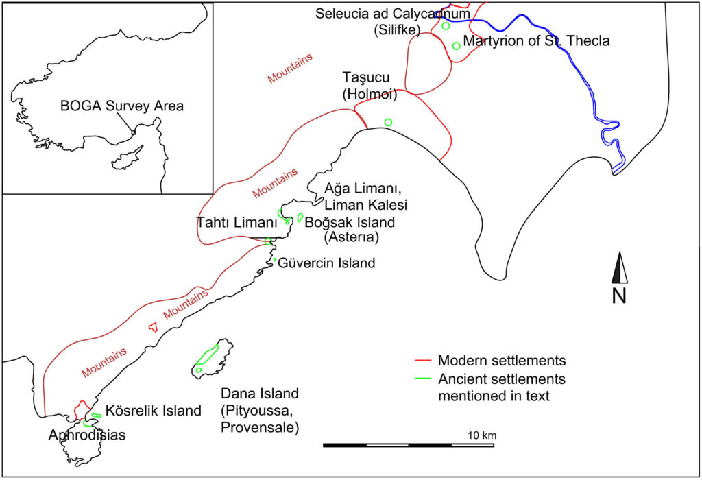
The Boğsak Archaeological Survey (BOGA), directed by Günder Varinlioğlu of Mimar Sinan Fine Arts University, is a diachronic field study of a 25 km-long stretch of the coast of eastern Rough Cilicia to the south and west of Silifke (ancient Seleucia ad Calycadnum). Favorable currents and winds made this coastline one of the favored sailing routes from Egypt and the Levant to points further west as early as the Bronze Age, while the proximity of Cyprus to Cilicia stimulated regional maritime trade. The BOGA survey region includes a mountainous inland area, a coastal strip from Taşucu (ancient Holmoi) in the east to the Ovacık Peninsula in the west, and four islands, all of which feature extensive archaeological remains. Evidence for early activity in the region primarily consists of Classical or pre-Classical period rubble wall fortifications and a major Hellenistic defensive wall (with Roman-Late Antique modifications) built of polygonal masonry on the Ovacık Peninsula.
During late antiquity (4th-7th century CE), the region saw significant maritime traffic—much of it likely related to the government-subsidized annona trade with Constantinople—as well as a boom in settlement, church construction, and an influx of pilgrims to local holy sites such as the Martyrion of St. Thecla on the outskirts of modern Silifke. Isauria (as the province was known in this period) was famous for its skilled masons and builders in the late 5th and 6th centuries. These craftsmen worked on some of the most important construction projects of the day (some likely commissioned by emperor Zeno, a native of the region), including churches and monasteries from Syria and the Levant to Hagia Sophia in Constantinople; during the same period, Isaurians were also prominent in the Byzantine army. Pottery finds from Boğsak Island indicate a continued Byzantine presence into the 12th century, but study of the region’s medieval and post-medieval settlement history is still in its early stages.


Two of the islands in the BOGA survey area, Boğsak (ancient Asteria) and Dana (ancient Pityoussa), feature dense architectural remains dating primarily to the Late Antique period, the most prosperous period in Rough Cilicia’s history. During this period the 7 ha Boğsak Island was the home of a settlement, surveyed by the BOGA team since 2010. Dana Island, the largest island in the survey area, is the site of an early Classical fortification and extensive evidence for settlement and limestone quarrying activities dated to the Roman and Late Antique periods, with a peak of activity from the 5th to 7th century CE. This is currently the largest Roman and Byzantine quarry site of its kind identified on the southern coast of Anatolia; stone blocks cut at these island quarries were exported by sea to construction sites along the coast. More information about these coastal rock-cut features has been published in Under the Mediterranean I, Studies in Maritime Archaeology.
The KUDAR-supported Maritime Archaeology team in BOGA has conducted two seasons of shoreline and snorkel surveys around the islands and harbors of the survey area in 2017 and 2018. The main research goals of the maritime survey are to:
1) Identify the presence and function of coastal settlements and fortifications, maritime installations, harbors and anchorages, rock cuttings, shipwrecks, and any other evidence for ancient maritime activity in the survey area;
2) Research evidence for economic production related to maritime trade, including coastal or island quarries, wine and olive oil production etc. as well as trade goods imported by sea;
3) Explain the role of seafaring and maritime activity on the inhabitants of eastern Rough Cilicia, particularly during the apparent population and construction boom of late antiquity. Why was this region so wealthy and populous in the Roman and Byzantine periods and (at least apparently) a relative backwater during other periods? This was certainly due to a variety of environmental, political, and cultural factors, including conditions for seafaring, but many of the details of the region’s history remain obscure.
Further survey work is planned for 2021 with a team of Koç University graduate students.
Publications
Varinlioğlu, G., N. Kaye, M. Jones, R. Ingram, and N. Rauh. 2017. “The 2016 Dana Island Survey: Investigation of an Island Harbor in Ancient Rough Cilicia by the Boğsak Archaeological Survey (BOGA).” Near Eastern Archaeology, 80.1: 50-9. (also available here)
Varinlioğlu, G., N. Kaye, M. Jones, R. Ingram, N. Rauh. 2017. “2016 Yılı Dana Adası Yüzey Araştırması: Boğsak Arkeolojik Yüzey Araştırmasının Antik Dağlık Kilikya’da Bir Ada Limanındaki İncelemeleri.” Arkeoloji ve Sanat 1 55 (Mayıs-Ağustos 2017): 149-60 (Journal of Archaeology and Art 1 55, May-August 2017).
Jones, M. R., 2020. “The Rock-cut Shoreline Features of Dana Island and the Maritime Landscape of the Taşucu Gulf, Rough Cilicia.” In Under the Mediterranean I, pp. 343-362, edited by L. Blue and S. Demesticha. Sidestone Press.