Conferences and Roundtable Discussions
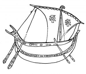
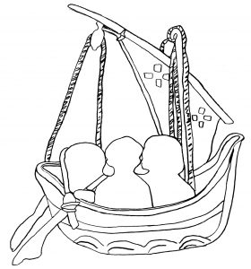
Ship Iconography in Anatolia and the Mediterranean World: Technology, Context, and Symbolism in the Medieval and Post-medieval Periods (May 2, 2023)
Date: May 2, 11:00 to 16:20 (Turkey)
Zoom Link: https://kocun.zoom.us/j/93854156833
Meeting ID: 938 5415 6833
Passcode: 680649
Ship depictions in public art, manuscripts, or as graffiti in public places are a rich but often underappreciated source of evidence for the various roles of ships in premodern societies. Past research on ship iconography has tended to focus on certain aspects of these depictions over others. Maritime archaeologists and historians have long recognized their value for understanding the development of ship construction and seafaring technology, while scholars of ancient religion and culture focus on ship depictions’ symbolic function and context in archaeological sites. While these perspectives are sometimes integrated in archaeological studies, typically one of these approaches to the evidence is emphasized over the other. Moreover, much of the work on ship iconography in the Mediterranean tends to focus on the numerous Roman and pre-Roman depictions rather than those of later periods.
This online symposium will explore research on ship iconography in Anatolia and neighboring regions from the late antique to late Ottoman periods, and will approach ship depictions from two different perspectives. Firstly, iconographic depictions remain essential sources of evidence for the technological development and everyday operation of medieval and post-medieval ships: they are particularly important for contextualizing the growing number of archaeological finds of well-preserved rigging elements and ships’ equipment discovered during excavations of Byzantine shipwrecks and harbor sites in the eastern Mediterranean.
Secondly, ship depictions also serve as physical evidence associated for a wide variety of beliefs, and ideas, ranging from religious, funerary, and magical practices to identification with specific groups, or, more simply, decoration or the relief of boredom. Since the physical context of these depictions frequently provides clues to their function, the context and documentation methods of ship graffiti and ship depictions will also be discussed. We hope to provide a comprehensive and interdisciplinary view of ship iconography in order to advance further research on this category of material in Turkey and neighboring regions.
Joint Online Roundtable with ARIT: National Jurisdiction in the Digital Realm (April 25th, 2021)
As part of a collaborative project with the excavation of Gordion (modern Polatlı) directed by the University of Pennsylvania, and with support from the US Embassy, KUDAR and the American Research Institute Türkiye (ARIT) hosted an online roundtable discussing National Jurisdiction in the Digital Realm. As a growing number of people are able to create and to disseminate digital models of the world around them, including the heritage that represents a nation, a diverse group of speakers discussed if or how a nation may attempt to regulate the dissemination of those models.
Our participants, including archaeologists and experts in AR/VR technology and Intellectual Property Law, had the opportunity to present their opinions as well as pose a number of important questions. All agreed that digital models of heritage – produced by private individuals or as a public service – have educational and management benefits. Moreover, the proliferation of low-cost photogrammetry techniques and online showcases means that more and more of these models will appear. The last consensus was that the management of the models’ creation, re-creation, and distribution will be a complex undertaking, prompting a number of important discussions:
1. Finding equity between a nation state’s use of digital models to promote their narrative, and individual interests using their own models to promote alternative narratives.
2. The role and applicability of copyright: Does an individual’s creation of the digital model give them copyright over the model, even if the subject may be ‘owned’ by the state?
3. How much national regulation is too much? Can it prompt the rebellious use of this technology and the models in opposition?
4. How can a nation state collaborate with the public within this new dynamic? Are there past examples – such as the clash between music labels, artists, and digital piracy that prompted streaming platforms – that could serve as a model?
A recording of our discussion is hosted on the ARIT YouTube page, available here.

Joint Heritage of the Maritime Micro-Region of Lesbos and Pergamon (November 10th-11th, 2019)
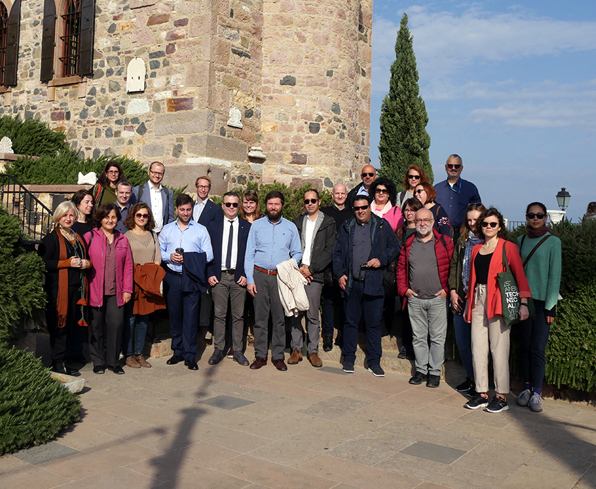
In collaboration with the Deutsches Archäologisches Institut (DAI), the American Research Institute Türkiye (ARIT), and ICOMOS Türkiye, and with gracious support from the Ayvalık Belediyesi and Sanat Fabrikası, KUDAR organized an international workshop to evaluate different ways of understanding the joint heritage throughout the maritime micro-region bounded by the island of Lesbos and the UNESCO World Heritage site of Pergamon / Bergama. From our perspective, this is an ideal environment for an extensive and diachronic study. The archaeological, textual, architectural, and historical records are extensive spatially and chronologically, while the present communities are emblematic of innumerable entanglements in the past and present.
Held in the historic town of Ayvalık, Türkiye, in the center of this micro-region, this multi-disciplinary event was an opportunity to explore how this region’s rich history is a narrative of ongoing entanglement, communications, migration, and interaction. Presentations from a group of international scholars occurred in the Sanat Fabrikası Tiyatrosu on November 10th and 11th, in front of an audience of approximately 60 scholars, local historians, and university students.


Dr. Alkiviadis Ginalis - Deutsches Archäologisches Institut, Istanbul
“From hinterland to foreland. Harbour network studies as indicator for micro-regional connectivity.”
Settlement activities along the coasts of Asia Minor are the result of increasing maritime communication and traffic since the Bronze Age. Although in recent years various scholars have been dealing with various aspects of maritime connectivity in the Eastern Mediterranean, especially the study of maritime trade in association with harbour works and other coastal infrastructures is still very sparse and lacks fundamental study. This is due to the fact that the coastal interrelation turns out to be not only of crucial importance but also of highly complex nature when it comes to understand its role as gateway for economic, social and cultural interactions. Coastal infrastructures were not independent and separate features acting as isolated phenomena, but rather linking elements and decisive factors for the execution and control of communication and commodification.Functioning as economic hubs, social meeting points as well as the main gate for cultural exchange, the study of harbour sites and their role within maritime connectivity therefore provides a rich new resource with which to understand cross-cultural dynamics.
However, maritime network systems can only be illuminated upon closer examination of the degree and pattern of interaction at micro-regional level. Therefore, this paper aims to present the network pattern between the hinterland and the foreland along the Asia Minor coast around Pergamon as a visualisation of local, regional and supra-regional connectivity.
Ms. Aylin Güngör - University of Hamburg
“Thinking through Maritime Hubs on the Coasts of Asia Minor and the Aegean Sea.”
When approaching ancient harbours and harbour cities the discussion of maritime hotspots, the so-called ‘emporia’, takes a special position within harbour research and the scholarly debate. However, the phenomenon ‘emporion’ remains unclear in the current theoretical discourse and lacks a coherent definition. In particular, the term which is generally understood as a landing or trading site stays incomprehensible regarding structure and layout. Nonetheless, maritime hotspots functioned as central elements in the organisation of trade and the exchange of goods in the Mediterranean and can be considered as a success story.
The previous research and attempts to classify these sites primarily dealt with economics, politics and society on theoretical basis. Recently, these maritime hotspots have been identified as playing a major role in cross-cultural exchangeHowever, a systematic study of the harbour structures of these settlements with a focus on topographical and architectural factors in the archaeological record has not yet been undertaken. At the outset, this paper outlines a classification and differentiation of maritime hotspots on the basis of a systematic study and acknowledges the importance of harbour research as integral part and parcel of ‘emporia’ studies.
It has been stressed that the written tradition of the ancient sources indicates a situation of blank spots on the map of Greek commercial harbours in the ancient Mediterranean. In response to this problem, the application of the developed criteria can be transferred to other sites that are not explicitly mentioned as ‘emporia’ in the sources and hence adapted to the region of Pergamon-Lesbos and their surroundings.
Dr. Annette Hoffmann - Kunsthistorisches Institut in Florenz, Max-Planck-Institut, Florence
“The Taxiarchis Icon of Mantamados and the Cult of Saint Michael in the Eastern Aegean”
It is narrated that, either in the ninth or tenth century or else in 1462, pirates – Saracens or Ottomans – attacked the monastery of St. Michael in Mantamados, on the island of Lesbos. Three pirates, the story goes, massacred all the monks except one, the novice Gabriel, who had hidden himself on the church’s roof. When the pirates found him there St. Michael appeared and raised his sword against them, after which they fled. Gabriel is said to have collected the soil soaked in the blood of his fellow martyred monks, shaping from it the image of the Archangel Michael. Earth steeped in the martyrs’ blood thus became a working material for an image. In this account, during the creative process the monk’s vision of the Archangel remained alive in his memory. While the legend appears to be written down only in the 20th century, the relief icon has been recently dated to the fourteenth century.
Around 1620, the Metropolitan Gabriel of Methymna recorded an abandoned small church dedicated to the Archangel Michael in the old part of Mantamados. In it there was also a relief icon of the angel, he wrote, guarded by women who thought that relief icons were idols “because this icon pictures the Saint with his whole head tangible”. This is the earliest description of the icon of Mantamados, and it is interesting in several respects. It expresses, on the one hand, a perceived relationship between the relief icon and idolatry. On the other hand, it mentions the paradox of the touchability of the (in itself incorporeal) angel. The paper will discuss the different material and immaterial aspects of the icon and its legend against the background of the traditions of images of St. Michael in Asia Minor and the Eastern Aegean.
Prof. Ahmet İçduygu - Koç University
“Mobility, Connectivity, and Territory-Making: Some Recent History from the Northern Aegean Sea.”
Dr. Yannis Kourtzellis - Hellenic Ministry of Culture & Sports, Ephorate of Antiquities Lesbos and Dr. Theotokis Theodoulou - Hellenic Ministry of Culture & Sports, Ephorate of Underwater Antiquities
“Harbours and relations between Lesbos and Asia Minor during antiquity. Connecting people, cultures and lands.”
Ancient literary and epigraphic testimonies preserve valuable information of the relations that the city-states of Lesbos developed with the coastal cities of Asia Minor at the opposite coast. The proximity of the island to the shores of Asia Minor led to the establishment of several Lesbian colonies in Aeolis and Troas regions during the Archaic period in the framework of the so called Aeolian Colonization. As a result the cities of Lesbos and especially the city of Mytilene seems to be strongly connected with the “Mytilenaean Peraia”, the so called “Aktaian Cities” (=coastal cities) and the “Shore of the Mytilenaeans” = (Μυτιληναίωναἰγιαλὸς).
Later on, from the Classical to the late-Roman periods, the island’s relations with the Aeolian and Ionian cities, including Pergamon, are mainly maritime oriented, commercial and inevitably political, known through agreements, degrees and treaties, in which two or more cities or federal “Koina”were included.
In our paper, taking into account the aforementioned we aim to present the layout and the development of the harbours of the cities of Lesbos, in the framework of a maritime micro-region.
Dr. Thaleia Kyriakopoulou - Hellenic Ministry of Culture, Lesbos
“Mytilene from Hellenistic to Roman times.”
Mytilene, the largest of the six ancient cities of Lesbos, on the east coast of the island opposite the Asia Minor coast, was in the Hellenistic and Roman times a city as beautiful as Rhodes and Ephesus, according to ancient writers. The city owed its special character to the natural strait of the Euripus, which divided it into two parts: on the “island” where the original settlement was located, and on the “mainland”, where it expanded after the end of the 4th century B.C.
The aim of this paper is to reconstruct the topography of ancient Mytilene from the Hellenistic to the Early Christian era, to the extent that it is possible, since rescue excavations conducted in modern residential areas inevitably provide a fragmentary pictureof the ancient material culture.The focus will be on the walls, the necropolises, the road system, the temples, the public buildings and the private residences, as characteristic elements of the urban form developing in close relationship with each other.
At the same time, an attempt is made to trace the common elements between Mytilene and Pergamon in terms of urban organization, architectural styles and decorative elements used for the embellishment of the public and private buildings.
Dr. Bernhard Ludwig - Deutsches Archäologisches Institut, Berlin
“Ways of Interaction within the Maritime Micro-Region of Pergamon and Lesbos.”
The “Kane Regional Harbour Survey”-Project as well as the Elaia-Project offered the chance to study a coastal micro-region, with a hierarchy of major and minor ports and bays and their relationship to Pergamon in a diachronic perspective. Furthermore, this region is also a good example to investigate the obvious changes in the importance and frequentation of harbours during the Roman and Hellenistic Period. But the inclusion of the nearby island of Lesbos with its ancient harbours and the study of the area as one maritime micro-region remains a desideratum. Therefore, this paper focuses on the different functions of harbours such as Elaia, Pitane, Kane and Mytilene and most of all on their ways of interaction within the Maritime Micro-Region of Pergamon and Lesbos. Interaction can take place on different levels (e.g. military-strategic or economic) and can be based on visual relations of coastal places or potential sea lanes, which are investigated with the help of GIS-based spatial analyses.
Assoc. Prof. Harun Özdaş - Doküz Eylül University
“The recent underwater archaeological survey in the Edremit Gulf.”
As part of the Shipwreck Inventory Project of Türkiye (SHIPT), an underwater archaeological survey was performed along the coast of Edremit Gulf in the northeastern Aegean Sea. During the expedition, side-scan sonar was used and scuba dives were carried out in order to detect and document ancient shipwrecks. SHIPT in Edremit Gulf resulted in the discovery of a total of eleven shipwrecks and several potential sites at depths between 2-38 m, dated from the Hellenistic period to 20th century. Five of the wrecks are located on the northern coast of the gulf. Another six wrecks are located to the south, near the town of Ayvalık. The main cargo of the shipwrecks generally consists of amphorae. One has historical significance. Among the wrecks, three are relatively well-protected. The best preserved shipwreck contains more than a thousand intact amphorae. The survey results demonstrate that the gulf was actively used during different periods. These recent discoveries contribute to seafaring history in the northeastern Aegean Sea, and thanks to the survey, areas of underwater cultural heritage in need of protection have been identified for government agencies.
Dr. Ayşegül Özer - Istanbul Technical University and Aristotle University of Thessaloniki
“Building Information System as a Tool in Architectural Heritage Management: The Case of Ayvalık”
Ayvalik is a historical city in the west Turkish coast of Aegean, near Ayvalık Gulf, in the Balıkesir Province. The urban texture consists of various traditional and monumental building types.The settlement is protected by the 2863 Law on the Conservation of Cultural and Natural Property.
The early establishment of the city is yet unclear (Ψαρρός, 2017: 29).The historic texture resembles a 19th century landscape despite the fact that its further past is hidden within or under the built environment.
Scholars commonly associate Ayvalik’s history with ancient Aeolis Αἰολίδα (Κοντής, 1978: 399-402; Ψαρρός, 2017: 29). The donation of 30 local families among group dating to 1653 may be the earliest document yet (Πατρινέλης, 1993: 13-21). On the other hand Ayvalik rises to its fame after a century with the privileges attained from Selim II in 1772 from, Καράμπλια (1949:81). The privileges create an economic, social and urban boost for the city: in addition to religious use or educational buildings it inheres health buildings further a mental clinic (Raffenel, 1822:201) serving to public. This rise is interrupted with revolve of the city and its support to the “New Greek State” in 1821. “Ayvalik Isyani Revolve” was quelled with force and private properties were confiscated (Arıkan, 1988: 579). After a decade, obligatory abandonment comes to an end regarding the decision of Mahmut II. The city, goes through another reconstruction/development period as understood from the descriptions (Καλφόγλους, 1899/2002:113). In the beginning of 20th century the population reaches 25.000 and the settlement extends nearly to today’s historic center borders: consists of 6000 houses, 5 consulates, 11 Orthodox churches, 1 mosque and 1 Catholic Chapel (Annuaire Oriental 1914: 1327).
After World War I, Ayvalik is invaded by British troops and immediately they handed over the city to Greek control, May 29th,1919. This status became permanent with the Treaty of Sévres and the city remained under Greek State rule till September 15th, 1922. The resolution of Greek-Turkish War (Turkish Independence War) with Greek defeat led to the Compulsory Exchange of populations by the Lausanne Peace Treaty (January 30, 1923). The exodus of Orthodox community from Ayvalik – which started earlier parallel to Smyrna incident – was finalized regarding to the Title: VI. Convention concerning the Exchange of Greek and Turkish Populations. Despite the fact that the city lost most of its inhabitants, it was re-settled by the communities arriving from Greece, mostly from Mitilini Lesvos and Crete.
The research with the title “Conservation Policies in Greece and Türkiye for Architectural Heritage of 1923 Lausanne Treaty Exchanged Population: Comparative Study for Cities of Rethymno and Ayvalik” started in 2005, in AUTH Interdepartmental Program of Postgraduate studies “Protection Conservation and Restoration of Cultural Monuments”and is to be submitted. The thesis includes field survey for both cities in addition to the historic and archival research. All the data compiled from the field survey is transferred in Building Information System BIS database. The database created consists 5700 buildings data for Ayvalik. This paper aims to reveal the buildings under threat as determined through research and discuss the usage of BIS as a tool for preservation management of the architectural heritage.
Dr. Kokona Roungou - Hellenic Ministry of Culture, Lesbos
“The Aiolian Sanctuary of Klopedi on the island of Lesbos.”
The Aiolian Sanctuary at Klopedi, known in the literature for the two Archaic temples A and B, was an important religious centre at the heart of the island of Lesbos. The purpose of the current study is to present the monumental building projectof the sanctuary, which appears to have been based on earlier remains that came to light with recent excavations at the foundations of the two temples.
The long history of the sanctuary goes back to the 8th century B.C. when on the ruins of a Mycenaean installation an oval building was built which housed the worship of a female deity. A funerary pyre that took place at about the same time outside the early temenos and an adjacent burial of the early Archaic times were carefully preserved in the foundations of Temple A and justify the unusual almost square plan of the building which erected shortly after the middle of the 6th century B.C.
On the other hand, Temple B, the main worship building, was erected at the end of the 6th century B.C. and included in its foundation all the earlier rectangular religious buildings that were constructed on the site in the 7th century. B.C.
The worship of Apollo in the Archaic sanctuary is witnessed by an inscribed roof tile in the name of the god, supporting the old assumptions about cult of Apollon Napaios at Klopedi.
Dr. Kokona Roungou - Hellenic Ministry of Culture, Lesbos and Thaleia Kyriakopoulou - Hellenic Ministry of Culture, Lesbos
“The rise and evolution of the city-states on the island of Lesbos.”
The island of Lesbos in nodal location in the NE Aegean region is rich in archaeological finds that date back to prehistoric times. The focus of the current study will be on the wide chronological frame between the Late Bronze Age and the Archaic period in an effort to trace the dynamics that led to the emergence and evolution of the six historical city-states of the island.
For this purpose, a synthesis of the most important of the archaeological sites of these periods on Lesbos is attempted, combining old and new excavation data. The location and distribution of the residential nuclei over the island, their interrelationships, the religious and burial customs as well as the ceramic tradition will be examined to identify the role of the Mycenaean background and the transitional Protogeometric and Geometric period in the formation of the Archaic city-states on the island of Lesbos.
Asst. Prof. Sercan Sağlam - Independent Researcher
“A Late Medieval Maritime Fortification Network for Lesbos.”
The massive towers on Büyük Maden Island of Ayvalık and Mardaliç (Corci) Island of Dikili were popularly and separately attributed to the noble Genoese family of Gattilusio, whose family lordship established in Lesbos lasted between 1355-1462. However, no scientific research handled those monuments in depth and above all attributed them to each other. Unclear aspects also include any related toponyms, detailed identity, and how those towers precisely functioned in the wider region. In fact, some modern research superficially mention the tower of Büyük Maden Island within the aforementioned popular context but especially this one still appears as an unstudied building. The other tower was previously investigated through its architecture and material characteristics. Accordingly, the same origin was proposed after a comparative study. Stories about the existence of a “Genoese” tower around modern Ayvalık dates back to the late 19th century but such accounts point somewhere else, where nothing remained today. It is also known that following the Fourth Crusade, many defensive towers and tower houses emerged throughout the Aegean Sea during the Late Medieval period. Thus, the towers in question could be classified into that larger group, which has a well established modern literature with further ongoing research. This paper aims to shed light on the origins and defensive purposes of those two towers through a detailed interdisciplinary methodology, including a geographical analysis for their specific positions on their islands; portolan maps and texts from various sources for possible toponyms; and an architectural investigation for further comparisons.
Prof. Turgut Saner - Istanbul Technical University
“The Aegean-Decorative Style (18th-19th c.) as a Common Ottoman Architectural Expression.”
The phenomenon called “Westernization” in Ottoman art and architecture is still a promising topic in spite of an already established scholarship of extensive written and said material. For instance, the way and the media, how the European styles were transferred to the Ottoman art or the determining economic and political circumstances of the time are among essential aspects. In addition, the individual shares of Istanbul and the provinces near and far including thereby the role of geographical positioning to stimulate interactions, and the related flux of forms are still problematic issues. The readiness of people with particular visual habits and traditions to welcome new (European) forms and make them gradually their own, further, the artistic and architectural expressions created by different Ottoman nations in terms of tools of identity, they all embody many striking questions.
The architecture of the Aegean Asia Minor, including the islands, presents many examples of the prevailing decoration of the 18thand 19thcenturies under European influence. The architectural relics from the same period in and around Bergama today provide features of floral and figural motifs carved on stone, as well as of wall paintings revealing common decorative approaches of the historical inhabitants of the region. This paper aims to contribute to the above-mentioned discussions based on the language of art and architecture.
Prof. Neriman Şahin-Güçhan - Middle East Technical University
“The Ayvalık Industrial Landscape: Current experiences and on-going conservation work in Ayvalık’s efforts to be a UNESCO World Heritage Site.”
Ms. Secil Tezer-Altay - Deutsches Archäologisches Institut, Istanbul
“Society and Architecture in Lesbos and Bergama throughout the 19th and 20th centuries.”
Assoc. Prof. Murat Tozan - Ege University
“‘The Road to Hippon’: Some Ancient Routes and Toponyms on the Kozak Mountains between the Mytilenaian Peraia and Pergamon.”
The Mytilenaian peraia covered roughly the coastal area between modern Ayvalık and Dikili town centers during a large part of the antiquity. While this peraia remained to be under the Mytilenaian hegemony, the Pergamene socio-political influence in the region gradually expanded pursuant to the rise of Pergamon as a metropolis in the Hellenistic period. Thus, the Mytilenaian peraia, which could also be regarded as an extension of the Pergamon micro-region, became a common contact area between two cities during the Hellenistic and Roman periods. The connection of the peraia with Mytilene was naturally through the sea. The routes connecting the peraia to Pergamon, however, extended over the mountainous region along its east, which is today called Kozak, or on lower slopes of these mountains. This paper examines the ancient toponyms of this mountainous region, the possible routes extended over region connecting the Mytilenaian peraia and Pergamon and the localizations of the ancient settlements on these routes. Thus, the strategic and economic importance of the Kozak mountainous region for the maritime micro-region of Lesbos and Pergamon in the antiquity will be discussed from a diachronic and holistic perspective.
Dr. Marek Vercik -Univerzita Karlova
“Metals on the Move: Metallurgy and Technological Transfer along the East Aegean / West Anatolian Littoral.”