Research at KUDAR
The Hellenistic-era Causeway at Klazomenai
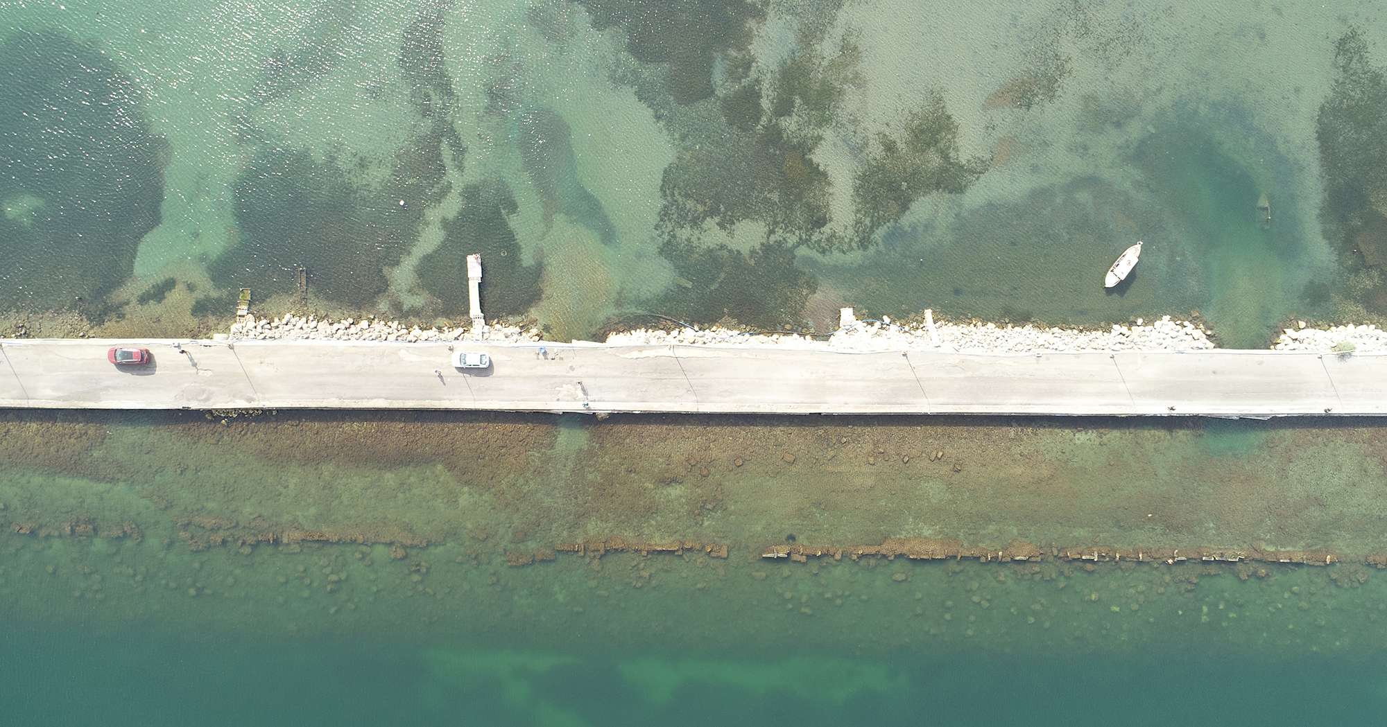
KUDAR is collaborating with scholars from the University of Ankara, Izmir Yaşar University, Mimar Sinan Fine Arts University, and Osmaniye Korkut Ata University to study the structure, use, and re-use of a Hellenistic-era causeway near the modern town of Urla, Turkey. This 400-meter long submerged structure joins the mainland to Karantina Island, and embodies the complex history of the region from the Hellenistic era to the modern day.
Project Background
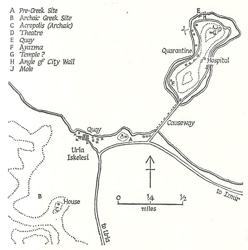

As part of the ongoing archaeological studies of Liman Tepe and Klazomenai by the University of Ankara and Yaşar University in Izmir, this collaborative investigation of the 400m-long submerged artificial structure joining Karantina Island to the mainland is an effort to understand its chronological phases, its use and re-use within different empires, the relationship with the surrounding natural environment, and to help develop plans for its management in the future.
Some myths suggest this structure was commissioned by Alexander the Great to join the mainland to a small island just offshore and to figuratively join the two adjacent communities, remnants of this causeway and its later modifications are still present in the littoral zone of Urla’s small modern harbour, in the Bay of Izmir. Pliny the Elder (5.31) and Pausanias (7.3.9) both mention the structure – and Alexander’s legendary role – in their descriptions of the area. Intermittent modification in the following centuries preserved the structure for later visitors as well. Bernard Randolph visited in the late 17th century, Richard Chandler in the 18th century, and the Reverend Robert Walsh a century later. Basic dimensions are provided by these past texts. It was approximately two stadia long according to Pliny, whereas Randolph and Chandler suggest it was approximately 30 feet (c. 10m) wide, and a quarter of a mile long (c. 400m). Chandler also wrote about the general state of the structure, with a thick wall preserved to the west and loose pebbles to the east, but the evident demolition and removal of the causeway’s large masonry as well. John Cook, in 1954, described the structure as part of his topography of Klazomenai in Archaiologike Ephemeris (1953-4), as did George Bean in his guide, Aegean Turkey (1966), and in the Princeton Encyclopedia of Classical Sites (1976).
More recently, the causeway has been a intermittent subject of research by scholars associated with the excavations of Klazomenai by Yaşar University and Mimar Sinan Fine Arts University, and with ANKUSAM, the University of Ankara’s maritime archaeology research center investigating the earlier phases at nearby Liman Tepe. For the history of Klazomenai, the causeway was a key part of the settlement’s infrastructure much like the associated harbour facilities from the Archaic and Roman eras; understanding the feature’s history thus adds significantly to the study of the city itself. Both teams have conducted geo-morphological and historical studies of the coastline (Goodman et al. 2008a and b), and remote sensing investigations of the seafloor (Müller et al. 2009), which establish the evolving environmental context of the feature. Among other places, the causeway was also nominated to be a protected geosite in 2020, as a rare example of natural and human-made geological phenomena ideal for tourism and education (Sümer et al. 2020).
There is a fundamental environmental component to this feature as well. As much as its construction joined two separate landmasses, its presence also divided a single body of water into two fairly different components. Waters to the west have stronger currents and wave activity; the prevailing winds from the NNW and NNE can generate whitecaps in these waters that break over the causeway. Storm winds can prompt waves up to 1.5m high (Sayın 2003; Goodman et al. 2008a). The eastern half, however, is distinctly calmer. Combined with the prevailing longshore currents from the east, the eastern bathymetry is comparatively shallow: depths over 15m are not found less than 500m from the shore (Sayın 2003; Goodman et al. 2008a). The causeway has bifurcated the coastline too – coarse pebble beaches to the west are contrasted to the shallow and fine-grained beaches to the east. With its prevailing currents and calm waters, there is much more coastal alluviation to the east as well, generating a particularly asymmetrical coastal silhouette. Last is the causeway’s relationship to sea level. As the waters in the area have risen approximately two meters since the Hellenistic era, the causeway required periodic changes to maintain its functionality. While it may have kept people dry when it was first created, subsequent additions were apparently submerged by the Ottoman era according to visitors’ texts. Randolph (1687) wrote how the structure was almost ‘consumed’ by the water, and Chandler (1776) described the waves breaking over the structure and almost reaching their horses’ bellies as they crossed. Walsh described similar conditions. The present roadway, constructed as early as 1930 on older levels and two meters above the current sea level, is the most recent iteration of this longstanding practice of construction and modification.
Fieldwork and Research Goals
For past visitors like Chandler, Randolph, Walsh and others, the causeway was a historical curiosity. It could act as a topographical landmark that confirms the location and orientation of Klazomenai in the ancient landscape. Its mythological link with Alexander, however, could also give visitors a visceral sense of communing with the past. In contrast to its utilitarian and mundane character, there was still a thrill of using this feature as Alexander may have – walking in his footsteps over a structure still serving the same purpose centuries later.
This association with Alexander is one of the questions we are investigating as we continue this project. Pliny the Elder and Pausanias, for example, emphasize Alexander’s role, but other authors do not. Klazomenai is only mentioned once in Arrian’s Anabasis (7.19), as the home of Miccalus , who was sent to Syria and Phoenicia. Descriptions of the city by Strabo (14.1.36) and Pomponius Mela (1.89) do not mention Alexander or a man-made causeway. Strabo does describe the settlement – like Tyre – as a peninsula that was once an island, but due to earthquakes well before Alexander’s time (1.3.17). This attribution to Alexander may have been Pliny’s and Pausanias’ contribution to emerging Alexander romances in the early Empire, and critical textual analysis is one approach to resolving this issue. A second is archaeological, and deciphering the chronology of the structure itself. If the foundations of this feature date before the 4th century BC or well afterwards, then not only does Alexander’s role change, so does the history of the settlement.
Understanding the foundations of the feature relate to deciphering the chronology and phases of the causeway too. To remain functional as the relative sea level rose from one century to the next, the causeway needed to be amended by increasing its height. By the 1930s a single-lane road was evident on the structure and, within the following two decades, it was expanded to accommodate traffic in two directions, similar to the roadway today. But, what modifications occurred prior to the modern era, when did they occur, and what was done? Randolph, Chandler, and Walsh each write that the causeway’s surface was near sea level during their visits; as the waters had risen approximately two meters since antiquity, this implies changes to the structure as well. A second line of research will investigate how the causeway structure changed over time, and when these changes may have occurred.
Support and Partners

Bibliography
Bibliography
G. Bean, 1976. ‘Klazomenai’ in R. Stillwell, W. Macdonald and M. Holland (eds), The Princeton Encyclopedia of Classical Sites.
G. Bean, 1979 (2nd ed.), ‘Clazomenae’ in Aegean Turkey, 99-106.
R. Chandler, 1776. Travels in Asia Minor, or, An account of a tour made at the expense of the Society of the Dilettanti, volume I.
B. Goodman, E. Reinhardt, H. Dey, J. Boyce, H. Schwarcz, V. Şahoğlu, H. Erkanal and M. Artzy, 2008. “Multi-proxy geoarchaeological study redefines understanding of the paleocoastlines and ancient harbours of Liman Tepe (Iskele, Turkey)” Terra Nova 21, 97-104.
B. Goodman, E. Reinhardt, H. Dey, J. Boyce, H. Schwartz, V. Şahoğlu, H. Erkanal, M. Artzy, 2008. “Evidence for Holocene Transgression and Shoreline Progradation Due to Barrier Development in Iskele, Bay of Izmir, Turkey” Journal of Coastal Research 24, 1269-1280.
G. Long, 1854. “Clazomenae” in William Smith (ed.), Dictionary of Greek and Roman Geography: Abacaenum-Hytanis, volume I, 631-632.
C. Müller, S. Woelz, Y. Ersoy, J. Boyce, T. Jokisch, G. Wendt, W. Rabbel, 2009. “Ultra-high resolution 2D-3D seismic investigation of the Liman Tepe / Karantina Island archaeological site (Urla / Turkey)” Journal of Applied Geophysics 68, 124-134.
Pausanias (trans. Jones), Description of Greece.
Pliny the Elder (trans. Mayhoff), Natural History.
B. Randolph, 1687. The Present State of the Islands in the Archipelago, or Arches, seas of Constantinople and Gulph of Smyrna with the Islands of Candia and Rhodes.
E. Sayın, 2003. “Physical features of the Izmir Bay” Continental Shelf Research 23, 957-970.
Ö. Sümer, M. Akbulut, Hülya İnaner, 2020. “New geosite candidates from Urla (Izmir, Western Anatolia, Turkey): a list of geological assets nested with antique and modern cultural heritage.” Turkish journal of Earth Sciences 29, 1017-1032.